
This first section of the Round Berkshire Cycle Route will take you from one of the busiest parts of the county to some of the quietest parts. Heading generally west from Reading towards Lambourn and then to Hungerford this is undoubtedly the most scenic of the sections. The payback for this though is that it’s also by far the hilliest.
This first section contains the largest amount of signage for the route, but be warned that there were at least two signs we found in the Hungerford area that had been turned at some point and were actually pointing in the wrong direction.
Section 1 summary
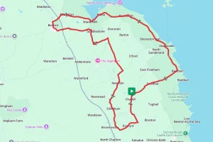
From the start at Caversham bridge in Reading the Round Berkshire Cycle Route goes along Richfield Avenue, and Portman Road until it meets the A329.
Heading west on the A329 the route then turns on to Overdown Road. From Overdown Road the route takes a series of quieter roads towards Sulham, where it then crosses over the A340 at Tidmarsh. Take care here as the crossing can be very busy.
After crossing the A340 at Tidmarsh it’s a quiet run along Tidmarsh Lane and Gardeners Lane to Upper Basildon. The route from here is a nice network of quiet lanes through Quicks Green and then on to the south side of Aldworth. From Aldworth you now ride along what is generally the northern county border, passing through Compton until you cross the A34 at East Ilsley. This part of the ride is one of the toughest with plenty of climbs to negotiate. The trade off for all this climbing though is spectacular views across the Berkshire / Oxfordshire border.
Once across the A34 it’s more of the same terrain and scenery as you ride uphill through West Ilsley and then take Copperage Road on to Farnborough and the highest point of entire 140 mile route. The reward for the climb up to Farnborough is a nice long downhill run straight in to Great Shefford and the gentle run through Eastbury and on to the heart of Berkshires racehorse  community at Lambourn.
From Lambourn the route now turns broadly south along the Bayden Road and Ermin Street to skirt the back of Membury services before crossing the M4 on Ramsbury Road. There’s now another network of quiet lanes to emerge just south of Upper Eddington before crossing the A4 and Kennet and Avon Canal to finish this section at Hungerford.
Start Point – Caversham Bridge, Reading
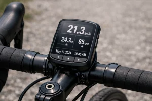
Distance – 42 miles / 67.5 km
Elevation Gain – 2362 ft / 720 m
Places Of Interest:
- Englefield Estate near Tidmarsh – just off route at 6.1 miles.
- Membury Camp – just off route at 36.2 miles.
- The Kennet & Avon Canal in Hungerford – at the end of the route.
Refreshment Stops:
Most villages along the have some sort of shop, pubs / cafe’s can be found at:
- The Greyhound pub Tidmarsh – at the 6.0 mile point.
- The Four Points pub Aldworth – at the 12.7 mile point
- The Crown and Horns pub East Ilsley – at the 17.2 mile point
- Goodies Cafe, Hight Street Lambourn – just off the route at the 32.3 mile point.
- The Tutti Pole, Hungerford – at the end of the route.
- Eliane of Hungerford – at the end of the route.
Local Bicycle Shops:
- Reading Bicycle Kitchen – Unit C10, Weldale St, Reading RG1 7BX
- Halfords Reading – Reading Retail Park, 709-723 Oxford Rd, Reading RG30 1PR (just off route at 2.0 miles)
- Jim the bike guy – 2 Sanden Cl, Hungerford RG17 0LB Tel 07500 505175
Closest Railway Station(s)
- Reading – Near to the the start point.
- Tilehurst – At the 2.8 mile point of the route.
- Hungerford – At the end of the route
Ride with GPS Link – https://ridewithgps.com/routes/35523862
GPX file, map & cue sheet direct download – Click Here
If you liked this route please consider supporting us by buying a tea at www.buymeacoffee.com/cyclinglabs