Wareham, Swanage and Corfe Castle

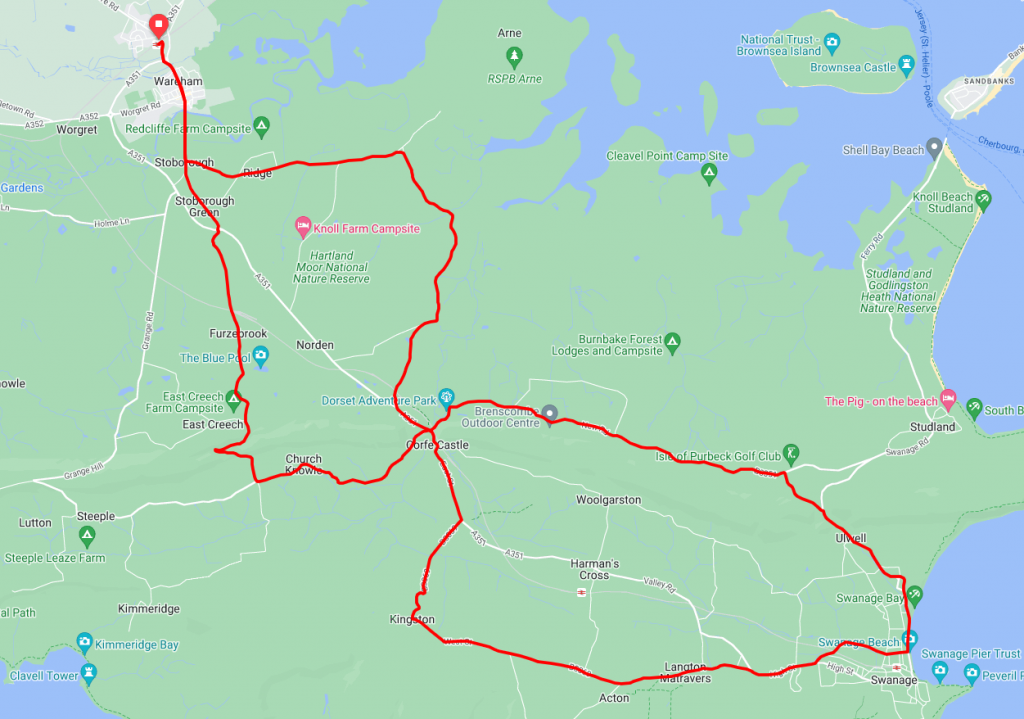
Starting in the Dorset town of Wareham and travelling to Swanage, this short route takes in a couple of steep climbs. It does however offer a lot to see and do along the way, so it can easily be extended out to an entire days ride.
Route Description
The route starts at Wareham railway station where trains run frequently and there is a car park if you wish to drive to the start.
From the station, take the route south through the town crossing the river Frome before turning left on Nutcrack Lane towards Arne. After about 2 miles take the right-hand fork to continue following National Cycle Network Route 2. Continue on this road for around 3 miles until you come to a roundabout to join the A351.
At this point, after about half a mile on the main ‘A’ road, take the left hand turning to the B3351. (Signposted ‘Studland’ and ‘Toll Ferry’). The route here now climbs (with the odd downhill respite) for about 3.5 miles but does offer some great views across Studland. (At this point, the ‘Studland Viewpoint’ is a good choice of places to stop and take pictures). Just before the Isle of Purbeck Golf Club take the right-hand turning onto Ulwell Road, through Ulwell itself and into Swanage town centre.
Following this, after Swanage town centre, the route ascends again while passing through Langton Matravers. Still climbing follow the B3069 until it peaks at Kingston. Keeping on the B3069 the route now turns north until it meets the A351 and Corfe Castle. Following this, after passing the Castle, take the left turning signposted to Church Knowle, Steeple, and Kimmeridge
From here the last climb of the ride begins in earnest as the road passes through Church Knowle. At this point, about a half mile past Church Knowle, you’ll arrive at a crossroads where you should turn right and continue the climb towards East Creech.
After cresting the hill shortly before East Creech it’s a pleasant and easy downhill run through Furzebrook before crossing the A351 and through Stoborough Green and Stoborough and back over the river Frome and in to the start point at Wareham Station.
Route Summary
Start Point – Wareham Railway Station
Distance – 26 miles / 41.5 km
Elevation Gain – 1768ft / 539 metres
Places of Interest
- Stoborough Heath National Nature Reserve – just off the route at the 2.3 mile point.
- Hartland Moor National Nature Reserve – just off the route at the 4.5 mile point.
- Swanage Railway Norden station – just off the route at the 6.0 mile point.
- Corfe Castle – on the route at the 6.4 and 19.1 mile points.
- Rempstone Stone Circle – on the route at the 8.8 mile point.
- Studland Viewpoint – on the route at the 9.6 mile point.
- Spyway National Trust – just off the route at the 15 mile point.
- Corfe Castle Model Village – just off the route at the 18.9 mile point.
- RSPB Stoborough Heath – just off the route at the 23.7 mile point.
Refreshment Stops
- There is an assortment of cafes etc in Wareham – at the start / finish
- The Village Inn, Ulwell- just off the route at the 10.9 mile point.
- There is an assortment of cafes etc in Swanage – on the route at the 12.0 mile point
- The Kings Arms, Lanton Matravers – on the route at the 14.3 mile point.
- National Trust Tea Rooms, Corfe Castle- just off the route at the 18.9 mile point.
- The New Inn, Church Knowle – on the route at the 20.9 mile point.
- The Cake House Tea Room, East Creech – Just off the route at the 22.2 mile point
Local Bike Shops
- Wareham Cycle Works – Train Station, Northport, Wareham BH20 4AS Tel 01929 556601
- The Bike Shop, Swanage – 5 Queen’s Rd, Swanage BH19 2EQ, Tel 01929 423215
Closest Railway Stations
- Wareham – at the start / finish (Network Rail)
- Norden / Corfe Castle at the 6.4 and 19.1 mile point (Swanage Heritage Railway)
- Swanage – Just off the route in the town (Swanage Heritage Railway)
Ride With GPS Link – https://ridewithgps.com/routes/33386556
GPX file direct download – Click Here
If you liked this route please consider supporting us by buying a tea at www.buymeacoffee.com/cyclinglabs
To see more great routes go to our Routes Index page


