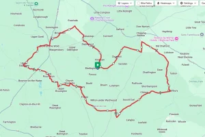

This section of the Round Berkshire Cycle Route maintains the mostly rural theme from the first section but having now moved to the southern part of the county is a lot less hilly than the first section. There are a couple of small hills, but the general profile is a gradual downhill.
From the Start in Hungerford the route generally follows the southern border of the county. The first part skirts Newbury before passing through Greenham, and Aldermaston. In the second half the roads get busier as they approach Bracknell before finishing close to Martins Heron railway station.
Section 2 Summary
From the start in Hungerford the Round Berkshire Cycle Route travels down Park Street before taking a southern turn along the Inkpen Road to Lower Green. From here it turns in an almost straight line through Upper Green, West Woodhay, Holtwood and Crockham Heath before crossing the A34 on Wheatlands Lane to emerge in Wash Common.
After Wash Common the route uses a few urban roads through a couple of housing estates to cross the busy A339. Once over the A339 the route then emerges at the edge of Greenham Common and follows Burys Bank Road along the northern edge of the common.
After leaving Greenham it’s a pretty straight run through Crookham Common and Brimpton before taking the Wasing Lane in to Aldermaston village. From Aldermaston the route meanders along Red Lane, Spring Lane and Raghill to emerge in to Padworth. where it turns along Silver Lane and the uphilll drag towards Mortimer.
After the crossing of the Burghfield Road it’s a short stretch to Mortimer and the chance for a well deserved break. If you fancy a small detour from the route the ancient Roman ruins at Silchester are close by.
 After leaving Mortimer it’s some rolling terrain for a few miles. The route runs through Spencers Wood, Swallowfield and on to Farley Hill. After crossing the A327 just after Farley Hill the route now passes through the recently re-developed ex-army base at Arborfield and on to the Barkham Ride towards Finchampstead.
At the end of Barkham ride the route crosses over the Finchampstead Road and onto Windsor Ride. This then crosses the Nine Mile Ride and on to Heath Ride and Roman Ride and eventually emerges close to Crowthorne railway station.
From Crowthorne station it’s a straight run along Dukes Ride and Bracknell Road before meeting the Nine Mile Ride. From this point the ride leaves the road as it takes a combination of cycle ways and residential roads to skirt Great Hollands and Birch Hill Estates. After Birch Hill the route emerges on the Nine Mile Ride before crossing the busy A322 by footbridge. Once over the footbridge it’s more of the same cycle trails and residential roads through Crown Wood and on to Martins Heron to cross the A329 and the end of this section.
From here it’s a short ride to Martin Herons railway station.
Start Point – High Street, Hungerford
Distance – 48 miles / 78 km
Elevation Gain – 2176 ft / 663 m
Places Of Interest:
- Walbury Hill at Inkpen – just off route at 3.6 miles.
- Greenham Common visitor centre – at the 14.0 mile point.
- Silchester Roman Ruins- approx 2 miles off the route at Mortimer.
- Caesars Camp Roman Encampment – at the 43.3 mile point of the route.
- Lookout Discovery Centre – at the 45 mile point of the route.
Refreshment Stops:
Most villages along the way have some sort of shop, pubs / cafe’s can be found at:
- The Tutti Pole, Hungerford – at the start of the route.
- Eliane of Hungerford – at the start of the route.
- Greenham Control Tower Cafe – at the 14.0 mile point on the route.
- The Hinds Head pub, Aldermaston – at the 21.1 mile point on the route.
- The Baobab Cafe, Mortimer – at 26.6 mile point on the route.
- The Golden Retriever pub, Bracknell – at the 43.3 mile point on the route.
Local Bicycle Shops:
- Banjo Cycles Newbury – 4 & 5, Norman House, Hambridge Rd, Newbury RG14 5XA
- Halfords Newbury – 2, Greenham Rd Retail Pk, Greenham Rd, Newbury RG14 7HZ
- Berkshire Cycles – 207 High St, Crowthorne RG45 7AQ
Closest Railway Station(s)
- Hungerford – At the start of the route
- Newbury – Near to the route at the 12 mile point.
- Mortimer – On the route at the 27.7 mile point
- Crowthorne – On the route at the 40.5 mile point
- Martins Heron – Approx 1.0 miles from the end of the route.
Ride with GPS Link – https://ridewithgps.com/routes/35524641
GPX file, map & cue sheet direct download – Click Here
If you liked this route please consider supporting us by buying a tea at www.buymeacoffee.com/cyclinglabs