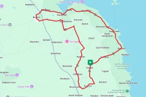

Barnstable and the Tarka Trail
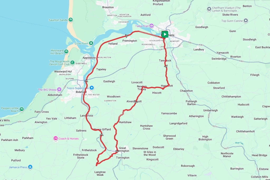
The Tarka Trail and Devon hills provide the backdrop for this ride of two halves. Starting in Barnstable, the first half of the ride takes in narrow lanes and also some testing climbs as it weaves its way to Great Torrington. From Great Torrington, the route then picks up the Tarka Trail for an essentially flat ride back to the start.
Note – Whilst the Tarka Trail is a paved off-road route, it is hemmed in by a lot of vegetation in places; consequently, the surface can be pretty ‘dirty’. As a result, we would recommend the use of a gravel bike or a road bike with wider tyres than normal.
Route Description
At the starting point at Barnstable railway station, look for the access road immediately in front of the station and follow it to the left and then under the A361 to the roundabout. From here, turn left and start the first climb of the day up Sticklepath Ct. and follow the road for a couple of miles to Tawstock. From Tawstock, carry on heading south towards Uppacott, taking the right-hand fork to Smemington after about half a mile and on to the climb to Uppacott.
Upon cresting the hill, relax on the downhill run to Harracot and turn right at the ‘T’ junction towards Newton Tracey. After just over half a mile, take the right-hand turning and then continue on to Newton Tracey village itself. Upon entering Newton Tracey turn left at the ‘T’ junction and then go south towards Alverdisscott. From Alverdisscott village, continue south along a combination of Abbaton Cottages Lane and then Guscott Lane to skirt Huntshaw Water and on towards Berry Castle Hillfort. From here, continue south and into the small town of Great Torrington.
Once in Great Torrington weave through the narrow streets and then cross the River Torridge. Immediately after crossing the river, follow the B3227 round to the right. After around 1.5 miles the route crosses a small bridge and then the Tarka Trail immediately afterwards. Take the right-hand turning, and you’re on the trail. The route along the trail needs no description from here as the rest of the ride is along the well-signposted trail, so enjoy the sights and the flat return to the start point in Barnstable.
Note – As has been noted, much of this route utilises very narrow and unmarked country lanes. Therefore, we strongly advise that you only tackle this ride if you are using a GPS navigation device and have downloaded the GPX file.
Route Summary
Start Point – Barnstable Railway Station EX31 2AU, O.S. Grid Ref -SS 55526 32537
Distance – 30.6 miles / 49 km
Elevation Gain – 2531ft / 771 metres
Places of Interest
- Berry Castle Hill Fort – just off the route at the 10.2 mile point.
- Tarka Valley Railway – on the route at the 16.5 mile point.
- Bideford Railway heritage centre – on the route at the 21.5 mile point
Refreshment Stops
- The Hunters Inn, Newton Tracey – just off the route at the 6.2 mile point.
- Torridge Inn, Torridge – on the route at the 13.1 mile point.
- Puffing Billy Cafe, Tarka Valley Railway – on the route at the 16.5 mile point.
- Toon Station Refreshments, Bideford Railway heritage centre – on the route at the 21.5 mile point
Note – The first half of this has almost no refreshment stops, so make sure you have some emergency snacks with you.
Local Bike Shops
Tee Bike Shed, Barnstable – The Square, Barnstaple, EX32 8LS, Tel 01271 328 628
Torrington Cycle Hire – on the Tarka Trail at the 16.5 mile point. Tel 01237 476509
Cycles Scuderia – The Pill, Invicta House, Kingsley Road, Kingsley Rd, Bideford EX39 2PF Tel 01237 476509
Closest Railway Stations
- Barnstable – at the start / finish point
Ride With GPS Link – https://ridewithgps.com/routes/54849540
GPX file direct download – Click Here
If you liked this route please consider supporting us by buying a tea at www.buymeacoffee.com/cyclinglabs
To see more great routes go to our Routes Index page