
Belper and Carsington Water Loop
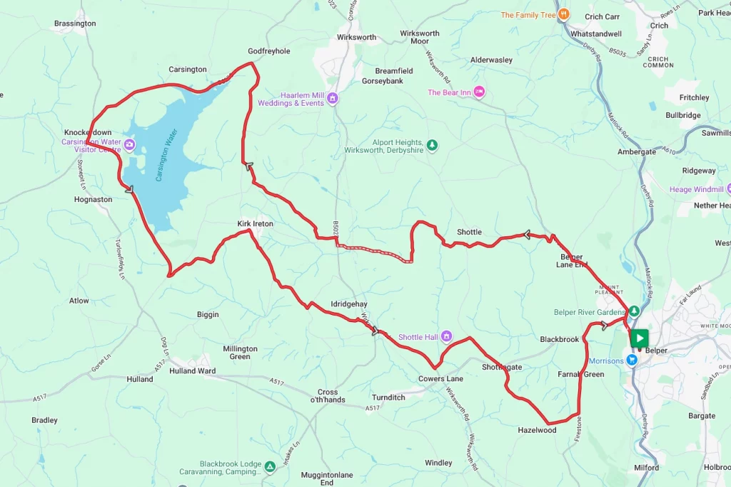
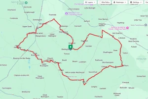
Belper and the Derbyshire Dales provide a great backdrop for this challenging ride. Starting in the small market town of Belper the route travels in a roughly north west direction to loop round Carsington Water before returning to the start. The ride takes in some stunning scenery, but there is payback in the form of a couple of fierce hills.
Note – Whilst this is in essence a road ride, some of the lanes may be muddy, especially after bad weather. This should be OK for most road bikes, but we wouldn’t recommend using anything with very skinny tyres.
Route Description
From the starting point at Belper railway station, take Field Lane and then Bridge Street to cross the River Derwent. After the river crossing, the route climbs steeply along Belper Lane and through the aptly named Mount Pleasant. Continuing the climb from here, the route now passes through Belper Lane End and then turns westward along Wilderbrook Lane. Once on Widlerbrook Lane, continue to the fork in the road and take the left-hand turning along Heavygate Lane.
From here, the route continues to use very quiet rural roads and lanes as it weaves through farm land along Lodge Lane and Top Lane. At the crossroads with the B5023 it’s a quick right and left dog leg onto Wood Lane before taking the right-hand fork to Tinkerley Lane. At the crossroads, continue straight over to Topshill Lane, and follow the route along Halfmoon Lane, Moor Lane and Stainsbro Lane and on to the north east corner of Carsington Water.
From this point, take the B5053 for around two and a half miles, following the north edge of Carsington Water, then at the junction with Dam Road turn left. Following Dam Road for its entirety along the edge of the reservoir. At the Junction with Gibfield Lane, turn left and follow the road into Kirk Ireton village. From the village, take Broadway southbound and then ‘Gorses’ at the fork in the road. At the junction with Cliffash Lane take a left and then a quick right onto Windley Lane as you drop down into the Ecclesbourne Valley.
After crossing the Ecclesbourne river, the route climbs and meanders along quiet lanes to Shottlegate before crossing the A517 and on to the village of Hazelwood. From Hazelwood, the route runs along Goodwins Lane before turning north and dropping down through Farnah Green and back into the start point at Belper.
Route Summary
Start Point – Belper Railway Station DE56 1DA, O.S. Grid Ref -SK 34797 47600
Distance – 23.0 miles / 37 km
Elevation Gain – 2215ft / 675 metres
Places of Interest
- Ecclesbourne Valley Heritage Railway – just off the route at the 5.7 or 17.2 mile point.
- Carsington Water Visitors Centre – just off the route at the 11.9 mile point.
Refreshment Stops
- The Miners Arms Pub, Carsington – just off the route at the 10.0 mile point.
- Carsington Water visitor centre – just off the route at the 11.9 mile point.
- The Barley Mow Inn, Kirk Ireton – just off the route at the 15.1 mile point.
- The Railway Inn, Shottle – just off the route at the 18.4 mile point.
Local Bike Shops
- Pedalworx – Morrell Wood Dr, Belper DE56 0JD Tel 07969 701161
- Velo Bavarian – Foundry Ln, Milford, Belper DE56 0RN Tel 01332 8419503
Closest Railway Stations
- Belper – at the start / finish point
Ride With GPS Link – https://ridewithgps.com/routes/54639751
GPX file direct download – Click Here
If you liked this route please consider supporting us by buying a tea at www.buymeacoffee.com/cyclinglabs
To see more great routes go to our Routes Index page