
Mottisfont and Winterslow
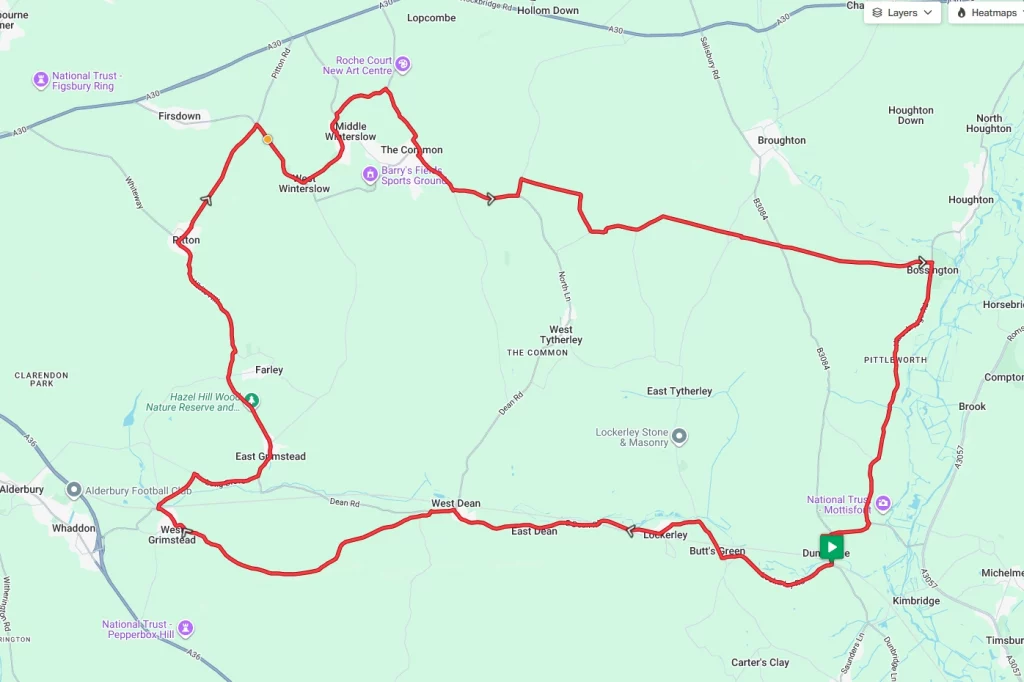
Starting in Mottisfont, this great little route will provide a good test but will also provide the base of a great day out. The National Trust property at Mottisfont is close to the start, so it can be explored either before the ride or after. There are also a couple of other interesting places to visit along the way, so prepare for a long day out. Utilising some parts of the National Cycle Network (NCN), the roads are generally very quiet, with the villages small and compact.
Route Description
From the starting point at Mottisfont and Dunbridge station, the route immediately picks up NCN 24 westbound towards Lockerley. Continuing on from Lockerly along NCN 24 the route starts to rise gradually as it criss-crosses the railway. Passing through East Dean and West Dean, the route turns left off NCN24 to head along Grimstead Road and on to West Grimstead.
From West Grimstead the route now turn north along Butter Furlong Road and Long Drove before emerging in to East Grimstead. Heading north along the Grimstead Road, the route climbs briefly before dropping down towards Pitton. From Pitton take the right-hand fork along Townsend and then the right-hand turning at the crossroads after about 1.25 miles. From here, the ride hits the only real climb of the route, fortunately the climb, while steep, is thankfully short.
After cresting the hill at West Winterslow, the ride follows the road route through Middle Winterslow and on to East Winterslow. Turning south after East Winterslow and through The Common. Shortly after leaving The Common, the route takes Tytherley Road, The Warren and Yew Tree Lane to join up with The Roman Road. Following the Roman Road, it’s a rolling three miles or so, crossing the B3084 before emerging onto the Horsebridge Road opposite Bossington Park.
After the T-junction with Horsebridge Road, it’s a right-hand turn southbound. Following the Horsebridge Road south through Pittleworth the ride soon passes Mottisfont National Trust. From here it’s a short run through Dunbridge to the start point at the station.
Route Summary
Start Point – Mottisfont and Dunbridge Railway Station SO51 0LN, O.S. Grid Ref – SU 31862 26158
Distance – 26.2 miles / 42.2 km
Elevation Gain – 1540ft / 469 metres
Places of Interest
- Hazel Hill Wood Nature Reserve – just off the Route at the 9.9 mile point.
- Mottisfont National Trust – just off the route at the 25.4 mile point.
Refreshment Stops
- Mill Arms – at the start / finish point.
- The Silver Plough, Pitton, just off the route at the 11.8 mile point.
- The Pump House Bakes, Middle Winterslow, just off the route at the 14.8 mile point.
Local Bike Shops
-
No local bike shops.
Closest Railway Stations
- Mottisfont and Dunbridge – at the start / end point.
- Dean – just off the route at the 4.4 mile point
Ride With GPS Link – https://ridewithgps.com/routes/54258185
GPX file direct download – Click Here
If you liked this route please consider supporting us by buying a tea at www.buymeacoffee.com/cyclinglabs
To see more great routes go to our Routes Index page