
Knaresborough and Wetherby Leg Killer
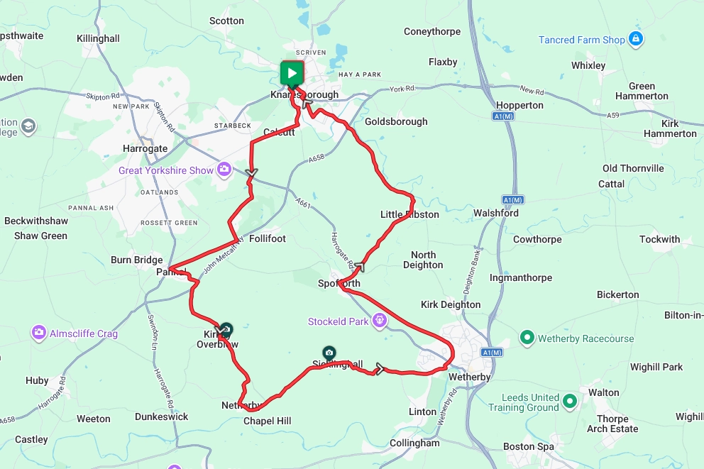
Starting in Knaresborough and winding its way to Wetherby and back, this is most definitely not a route for the faint-hearted. With 1500ft of climbing packed into a mere 23 miles, be prepared for some nasty up hills but also some glorious down hills. With some great views and places of interest along the way, coupled with abundant refreshment opportunities to rest those battered legs, this could easily be turned into an all-day ride. Note – This route utilises the Wetherby Railway path track between Wetherby and Spofforth. Whilst it should be OK for most bikes, if you prefer not to ride this track, take the Harrogate Road to Spofforth and re-join the route.
Route Description
From the starting point at Knaresborough railway station, pick up Water Bag Bank and then Waterside heading roughly south for about half a mile. At the junction with Blands Hill turn right and begin the climb out of town. Continue for approx another half mile before turning right on to Forest Moore Road. Continuing the climb, the route shortly turns south along Forest Lane before crossing the A661.
After Crossing the A661, the route now takes Rudding Lane to drop down Collins Hill before climbing again past Rudding Park. Shortly after passing Harrogate Rugby Club the route turns down Pannel Road and on to the outskirts of Pannel itself. Just after the Pannel golf club, the route turns left along Drury Lane and on to the juntion with the A658. From Here turn left and take a short stint along the busy ‘A’ road before turning left in to Follifoot Lane and following the road to Kirkby Overblow
From Kirky Overblow continue south along Barrowby Lane, keeping an eye out for the turning to Netherby, signposted Moor Lane. As you drop down in to Netherby, take a few moments to enjoy the views as you are about to hit the toughest climb as you leave the village. From Netherby take Kirkby Lane and follow the road through Sicklinghall and onto the outskirts of Wetherby. As you enter Wetherby keep an eye out for a left-hand turn signposted Harland Way. Take that in to the Car Park and the start of the Wetherby Railway Path. Follow this track all the way to Spofforth.
From Spofforth the route now takes the Harrogate Road and Ribston Road to Little Ribston before turning north along the Wetherby Road. Cross the A658 before weaving through the town and back to the start point at the railway station.
Route Summary
Start Point – Knaresborough Railway Station HG5 9AA, O.S. Grid Ref -SE 34812 57142
Distance – 23.0 miles / 37 km
Elevation Gain – 1519ft / 462 metres
Places of Interest
- Knaresborough Castle – just off the route at the 0.2 mile point.
- Spofforth Castle – just off the route at the 16.9 mile point.
Refreshment Stops
- Shoulder of Mutton Pub, Kirkby Overblow – on the route at the 7.6 mile point.
- Cow Corner Cafe, Sicklinghall – on the route at the 11.1 mile point.
- Londis Store & Bakery Spofforth- on the route at the 16.9 mile point.
- Watermill cafe, Wetherby Rd, Knaresborough- just off the route at the 21.5 mile point.
Local Bike Shops
- Wetherby Bike Shack – 9 The Horsefair Center, Wetherby LS22 6JG Tel 01937 588944
- Spa Cycles – 48 Camwal Rd, Harrogate HG1 4PT Tel 01423 887003
Closest Railway Stations
- Knaresborough – at the start / finish point.
- Pannal – just off the route at the 5.5 mile point.
Ride With GPS Link – https://ridewithgps.com/routes/54379687
GPX file direct download – Click Here
If you liked this route please consider supporting us by buying a tea at www.buymeacoffee.com/cyclinglabs
To see more great routes go to our Routes Index page