Rolling Hills In Kent

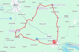
With just over 1300ft of climbing in 20miles, and some of them being as high as 11% this is most definitely not a route for the faint hearted. If you do decide to tackle this route though you will get to see some spectacular views across ‘The Garden of England”.
Route Description
This route starts at Selling railway station south east of Faversham. This offers some parking or easy access by train from Canterbury, Gillingham and the surrounding area.
From the start point at the station the route heads roughly south along the Selling Road and immediately in to a series of small climbs to warm the legs. After a couple of miles you now head downhill for a glorious run through Old Wives Lees and in to the small town of Chilham.
Although the route has only just started already it’s time for the first major climb of the day, so a break and a visit to Chilham Castle is recommended. After a short stretch along the A252 at Chilham the route turns north west to Shottenden, with a testing climb of 250ft over the next 1.5 miles.
Shottenden is the highest point on the route so from here the next few miles take a generally downhill slant as they follow some quiet country roads through Sheldwich and on to Throwley. The road out of Throwley presents yet another climb so typical of this route as it follows Bagshill Road before turning north along Stalisfield Road for a short stretch.
After a few miles of up and downhill along the Eastling Road and Faversham Road the route crosses the M2 before a short downhill stretch in to the outskirts of Faversham A refreshment break in Faversham is highly recommended as the last five miles back to the start are a constant uphill climb.
Shortly after leaving Faversham the route now heads south along the Selling Road. This is reasonably tough uphill climb for almost the whole five miles back in to Selling with just a short downhill dip before climbing up again as the route passes through Gushmere.
Route Summary
Start Point – Selling Railway Station
Distance – 19.6 miles / 31.5 km
Elevation Gain – 1308ft / 398.6 metres
Places of Interest
- Chilham Castle, Chilham – just off the route at the 3.0 mile point.
- Belmont House and Garden – just off the route at the 9.5 mile point.
- Faversham Stone Chapel (English Heritage) on the route at the 14.5 mile point.
Refreshment Stops
Note – refreshment stops in the middle of this route are non-existent. We recommend carrying your own refreshment if you want something mid-ride.
- Badgers Hill garden centre / Badgers Hill farm & cidery – just of the route at the 2.8 mile point.
- The Church Mouse Tea Rooms at Chilham – on the route at the 3.1 mile point.
- The Gunpowder Mill public house – on the route at the 16.6 mile point.
- Macknade foodhall & farm shop – on the route at the 16.6 mile point.
Local Bike Shops
- The Bike Warehouse 30-32 Preston St, Faversham ME13 8PE Tel 01795 539439
- Stevenage Cycles, 26 The Glebe, Stevenage, SG2 0DJ Tel 01438 340004
Closest Railway Stations
- Selling – at the start / finish
- Chilham – just off the route at the 2.9 mile point
- Faversham – just off the route at the 16.0 mile point
Ride With GPS Link – https://ridewithgps.com/routes/39083408
GPX file direct download – Click Here
If you liked this route please consider supporting us by buying a tea at www.buymeacoffee.com/cyclinglabs
To see more great routes go to our Routes Index page


