
Tisbury and the Ebble Valley
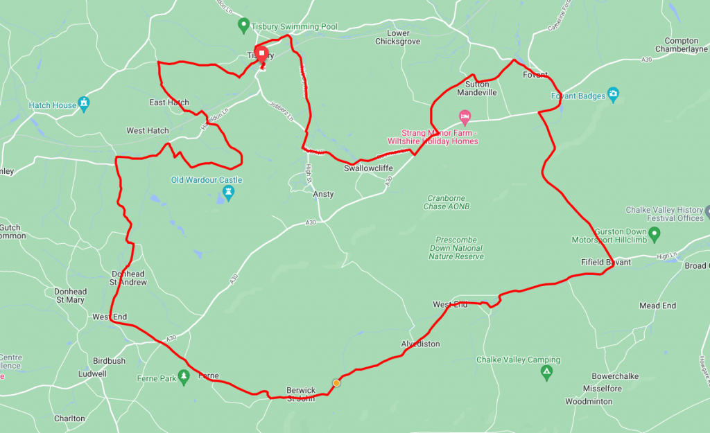
Starting in the small Wiltshire town of Tisbury this challenging route is not for the faint hearted. With approx 1700ft of climbing in 24 miles and a couple of climbs hitting the 10% gradient mark anyone taking this on is definitely going to need their climbing legs.
Route Description
The route starts at Tisbury railway station. Trains run frequently and there is a car park if you wish to drive to the start.
From the station, the route runs briefly through the High Street and Park Road before turning south on Tisbury Row From here it’s a rolling couple of miles or so into the small village of Swallowcliffe.
As you enter Swancliffe turn left on to Common Lane before hitting the A30 for a short (0.5 mile) stretch along this busy road. Once on the A30 look out for the turning on the left for Sutton Hill. As you would expect there’s now an uphill climb however this quickly turns downhill for the run in to Sutton Mandeville and Fovant.
After Fovant and a brief section along the A30 again it’s time to head south for the first major climb of the ride. For the next mile or so it’s a steep climb with gradients hitting 10-11% at times. Once you reak the peak of the climb take a few minutes for a breather and admire the views across Gurston Down before the equally steep descent into Fifield Bavant.
From Fifeld Bavant the route continues its hilly theme with a long slow five-mile climb through Ebbesbourne Wake, Alvediston and Berkwick St. John. Berwick St. John makes a great place for a mid-ride stop for lunch or a picnic.
Whilst the route now follows a generally downhill trajectory as it passes through Ferne and West End into Donhead it could probably be best described as ‘Rolling’ with a few little hills to test the legs. After Leaving Donhead St. Andrew the route skirts West Hatch and takes the climb up to and around Wardour Castle. A short sharp run from here takes you through East Hatch before the last climb of the ride through Tuckingmill and in to the start at Tisbury
Route Summary
Start Point – Tisbury Railway Station
Distance – 25 miles / 40 km
Elevation Gain – 1830ft / 558 metres
Places of Interest
- Castle Ditches Fort – just off the route at the 1.7 mile point.
- Chiselbury Ring – just off the route at the 7 mile point.
- Wardour Castle – just off the route at the 21 mile point.
Refreshment Stops
- An assortment of cafes etc at Tisbury – at the start / finish
- The Royal Oak, Swallowcliffe- on the route at the 3.1 mile point.
- TThe Greater Good Inn, Fovant – on the route at the 6.8 mile point
- The Horsheshoe Inn, Ebbesbourne Wake – just off the route at the 11.3 mile point.
- The Talbot Inn, Berwick St. John – on the route at the 14.6 mile point.
- The Forrester, Donhead St. Andrew – on the route at the 17.7 mile point.
Local Bike Shops
- Cranks and Planks, Unit E2A Grosvenor Road, Wyndham Business Park, Tisbury SP3 6GS, 07399 637049
Closest Railway Stations
- Tisbury – at the start / finish
Ride With GPS Link – https://ridewithgps.com/routes/39037544
GPX file direct download – Click Here
If you liked this route please consider supporting us by buying a tea at www.buymeacoffee.com/cyclinglabs
To see more great routes go to our Routes Index page