
Matlock Short Loop
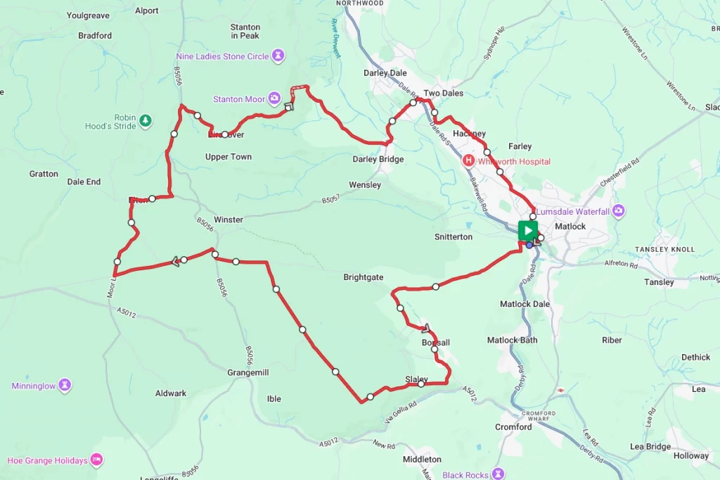
Matlock in Derbyshire is the setting for this short but spectacular ride. Nestled on the edge of the Peak District National Park in the Derbyshire Dales there are the inevitable climbs as well as some incredible views. Many of the roads on this route are single-width lanes, and the route is generally quiet and avoids too many towns and villages.
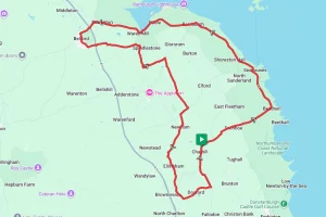
Route Description
From the starting point at Matlock Railway Station take the Snitterton Road and then quickly turn south on to Salters Lane / Nailors Lane before turning to Bonsall at the T-Junction. Follow the road through Bonsall village itself and take the right-hand turning down Black Tor Road. At the end of Black Tor Road take the left hand turning on to Leys Lane and follow it to the crossroads. When reaching the crossroads, continue straight over on to Bonsallmoor Lane.
At the end of Bonsallmoor Lane turn left at the T-junction and follow Bonsall Lane to the end. From here, it’s a quick right, left and left on to an un-marked narrow road. Follow this road to the crossroads and then turn right on to Moor Lane and follow the road in to Elton Village. After leaving Elton via Winter Lane take the left turn onto Dudwood Lane and follow this for about a mile before taking the right hand turn along ‘The Mires’ and in to Birchover.
After Birchover, the route winds along Lees Road in to Stanton Lees before dropping down to Darley Bridge. From here the route crosses the River Derwent and the railway line and then continues on to Two Dales. From Two Dales, the route takes Offord Road southbound as it weaves through Hackney and Lower Hackney. Finally the route hits the outskirts of Matlock before returning to the start at the station.
Note – As has been noted, much of this route utilises very narrow and unmarked country lanes. Therefore, we strongly advise that you only tackle this ride if you are using a GPS navigation device and have downloaded the GPX file.
Route Summary
Start Point – Matlock Railway Station DE4 3NA, O.S. Grid Ref -SK 29631 60196
Distance – 17.6 miles / 28.3 km
Elevation Gain – 2148ft / 655 metres
Places of Interest
- Cascades Gardens, Bonsall – on the route at the 3.0 mile point.
- Winster Market House National Trust – just off the route at the 7.0 mile point.
- Rowtor Rocks & Druids Cave, Birchovers – on the route at the 11.4 mile point
Refreshment Stops
- Fountain Tea Rooms, Bonsall – on the route at the 2.8 mile point
- Bank Top Cafe, Winster – just off the route at the 7.0 mile point,
- The Druid Inn, Birchover – on the route at the 11.4 mile point
- There are a number of independent and chain cafe’s etc in Matlock at the start / finish.
Local Bike Shops
- Stanley Fearn Cycles – 19, Bakewell Rd, Matlock, DE4 3AU Tel: 01629 582089
-
Crafted Cycles – Lumsdale Road, Matlock, DE4 5EW Tel: 01629 706620
Closest Railway Stations
- Matlock – at the start / finish point
Ride With GPS Link – https://ridewithgps.com/routes/54964822
GPX file direct download – Click Here
If you liked this route please consider supporting us by buying a tea at www.buymeacoffee.com/cyclinglabs
To see more great routes go to our Routes Index page