
Oxfordshire Leg-Stretch
This Oxfordshire cycling route starts at the Badbury Hill National Trust car park near Great Coxwell, which is a few miles north east of Swindon. This route is a combination of generally flat terrain with a couple of testing hills thrown in to keep you on your toes. There is plenty to see along the way, for this reason, we recommend leaving time to stop and explore. Using mostly quiet lanes this route will pass through lots of small villages and National Trust properties giving those that want to stop off and explore plenty of opportunity to turn this in to a full days cycle touring.
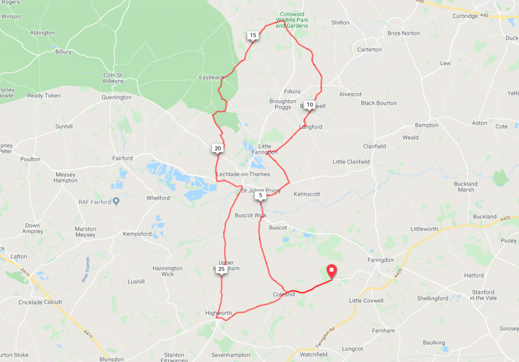
Route description
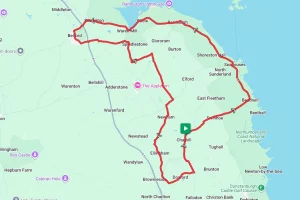
After leaving the start point at Badbury Hill the route travels downhill through Coleshill before turning north and skirting Buscot Park to St. Johns Priory and Little Faringdon.
From Little Faringdon the route now takes on almost exclusively country lanes as it passes through Langford, Bradwell, and Kencot before climbing to the most northerly point of the route at Bradwell Grove. After Leaving Bradwell Grove it’s a gentle downhill run, brushing the edge of the Costwolds at Eastleach and then crossing the River Thames at Lechlade.
After crossing the Thames the flat route continues for a couple more miles along the A361 before starting a short series of climbs through Highworth. Afterward, the route travels through Coleshill before returning to the start point at Badbury Hill.
Start Point – Badbury Hill National Trust
Distance – 30.7 miles /49.4 km
Elevation Gain -1284ft / 391.3m
Places Of Interest:
- National Trust Coxwell Barn, Great Coxwell – about 1.5 miles from the start point.
- National Trust Buscot Park – at the 4 mile point.
- Costswold Wildlife Park & Gardens at Bradwell Grove – at the 14 mile point.
- Riverside Park, Lechlade – at the 22 mile point
- National Trust Coleshill Mill – at the 29 mile point.
Refreshment Stops:
- Thr Trout Inn, at St. Johns Priory – at about the 5.5 mile point.
- The Oak Tree cafe at Costswold Wildlife Park & Gardens – at the 14 mile point.
- The Swan at Southrop – at the 18.5 mile point
- Most villages along the route have a shop and / or pub.
Local Bicycle Shops –
- Two Wheels Better – 3 Coxwell St, Faringdon SN7 7EA (approx 1.5 miles from the start)
- Push Pedal – mobile repairs, www.pushpedal.co.uk
Closest Railway Station(s)
- There aren’t any stations really close. However, Swindon is approximately 10.5 miles from the start.
Ride with GPS Link – https://ridewithgps.com/routes/31724017
GPX file direct download – Click Here
If you liked this Oxfordshire cycling route please consider supporting us by buying a tea at www.buymeacoffee.com/cyclinglabs