
Tring To Gaddesden Circular Ride
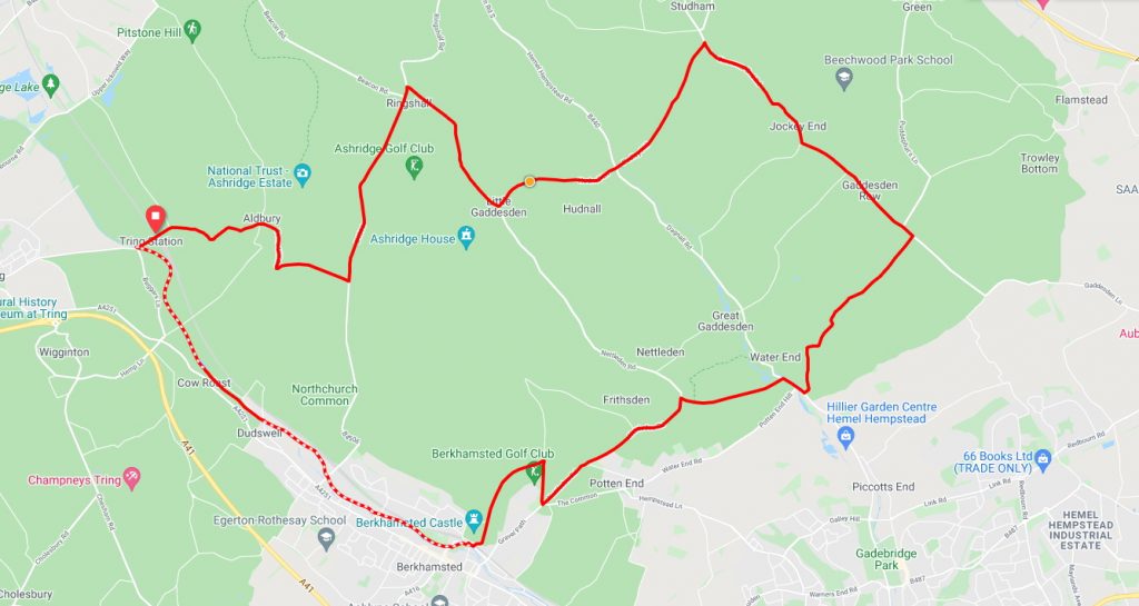
Starting in the Hertfordshire town of Tring this ride will take you through some lovely country side. Indeed you will quickly forget you’re only a few miles from London. At just over 20 miles and a little over 1000ft of elevation this is a slightly testing route. You will be rewarded however with some great views over the Hertfordshire country side. For such a short route there are plenty of pub stops along the way to refresh those tired legs.
Note – This route utilises the towpath along the Grand Union Canal for around the last four miles. The surface is quite good however we would suggest that this be ridden with tyres of around 32 – 35mm.
Route description
From the start point at Tring railway station car park it’s a gentle one mile warm up to Aldbury. From Aldbury you’re now in to the first testing climb of the day over the next half mile or so with gradients up to 10% to be tackled. Once you’re at the top of the hill you’ll be rewarded with some great views as you proceed through the National Trust owned Ashridge Estate. From Ashridge the route takes a gentle downhill run through Ringshall to Little Gaddesden.
After leaving Little Gaddesden its the first downhill of the route through Hudnall village but this doesn’t last long as its quickly in to the second climb of the ride as you cross the B440 and up in to Clements End. From Clements End the route runs gradually downhill now for about four miles running through the small villages of Jockey End and Gaddesden Row. Shortly after passing through Gaddesden Row the route takes a sharp right turn on to Red Lion Lane and sharply downhill in to the small village of Water End.
From Water End it’s now back on to a gentle uphill stretch before a sharp climb passing Potten End along the Nettleden Road. At the end of the Nettleden Road the route takes a quick right and left turn to skirt Berkhamsted Golf Club and then a swift downhill section in to the centre of Berkhamsted. After crossing the canal at Castle Street it’s straight on to the towpath heading roughly northward. This stretch of the canal is a gentle uphill stetch all the way back to the starting point in Tring.
Start Point – Tring railway station / car park
Distance – 20 miles / 32 km
Elevation Gain – 1168 ft / 356 m
Places Of Interest:
- National Trust Ashridge Estate – just off route at 3.0 miles.
- War Memorial – at the 15.3 mile point on the route.
- The Berkhamsted Mystery Treasure Trail – just off the route at 16.3 mile point
Refreshment Stops:
- Musette Cafe – at the 0.9 mile point.
- Brownlow Cafe, National Trust Ashridge Estate – just off route at 3.0 miles.
- The Crown & Sceptre pub – at the 11.5 mile point
- The Red Lion pub – at the 12.2 mile point
- A large assortment of cafes, pubs, etc in Berkhamstead
Local Bicycle Shops:
- Mountain Mania Tring, 4-6 Miswell Lane, Tring, HP23 4BX, 01442 822458
- Road Room Tring, 10 Miswell Lane, Tring, HP23 4BX, 01442 828096
- Lovelo Cycle Works Berkhamstead, Unit 7 Dwight’s Yard, r/o 167 High Street, Berkhamsted, HP4 3HB, 01442 873000
Closest Railway Station(s)
- Tring – at the start / finish point.
- Berkhamsted – at the 15.2 mile point of the route.
Ride with GPS Link – https://ridewithgps.com/routes/35758898
GPX file direct download – Click Here
If you liked this route please consider supporting us by buying a tea at www.buymeacoffee.com/cyclinglabs