
Climbing Hills In The Chilterns Around Henley
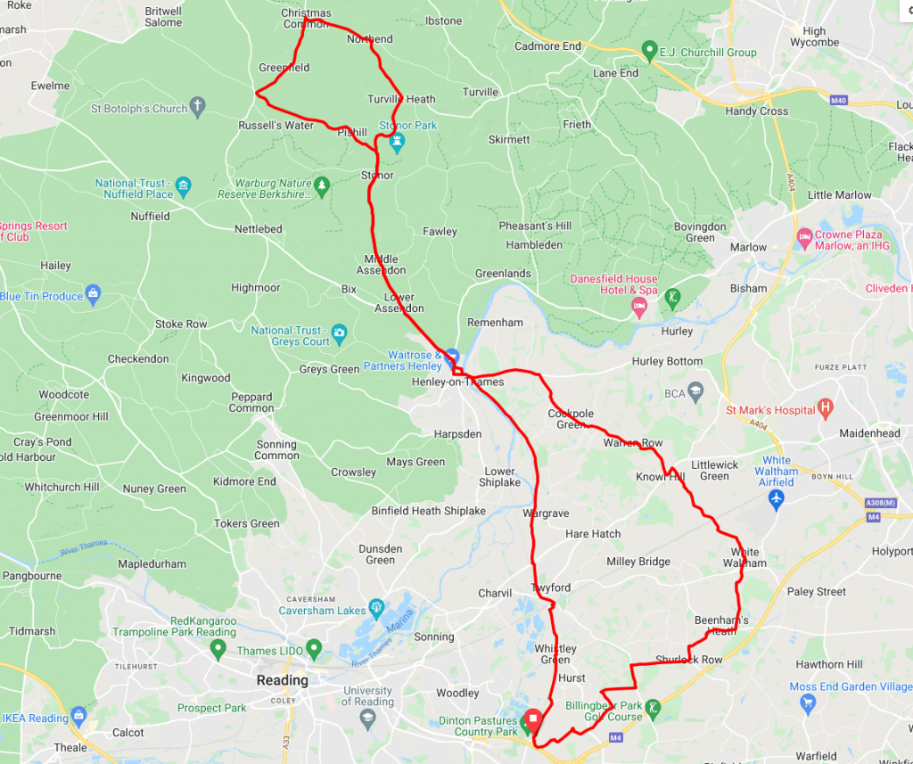
Starting at Dinton Pastures Country Park just outside Wokingham, this route will then take you through the south Oxfordshire town of Henley-On-Thames and in to the Chilterns for a little hill climbing. This route has one long steady climb and one short, sharp climb, which will certainly test the legs of any aspiring mountain climber.
Route description
From the start point at Dinton Pastures the route runs generally northward. Following ‘B’ roads and minor ‘A’ roads through Twyford and Wargrave. Between Twyford and Wargrave the route crosses the A4 which can be busy. With this in mind, we recommend using the footbridge here to cross the road.
After passing through Wargrave it’s a rolling three mile or so run in to Henley-On-Thames on a minor but slightly busy ‘A’ road. Once in Henley you will find plenty of places to stop for refreshment before negotiating the one way system out of town along the Fairmile. Whilst cycling along the Fairmile we suggest using the cycle path as it will put you on the right side of the road to take the turn toward Assendon.
After leaving Henley, it’s the start of a long 8.5 miles of uphill climbing. Once you have traversed the Fairmile the next step is to take the turning right on the B480 towards the Assendons and Stonor. Here you will start to feel the gentle, gradual rise of the road. After passing through Lower and Middle Assesndon and the entrance to Stonor Park you will be at the foot of Pishill and the steepest part of this climb. At the fork in the road just past Stonor, take the left road and the Pishill climb will begin in earnest. After about three miles at the top of the steepest part of climb take a right turning toward Christmas Common. From here, the route now goes back down the hill through Northend and Turville Heath before rejoining the outbound road at Stonor and back into Henley.
Once you have renegotiated Henley it’s on to the last major climb of the day at Remenham Hill. This is on an ‘A’ road and consequently may be busy. For those who want a quieter and easier climb, you can divert via Remenham and Aston Villages and subsequently re-join the route at the top of the hill. Remenham Hill is the last climb, as a result there is the chance to rest the legs for a while. Travelling through Warren Row, and across the A4 at Knowl Hill before skirting White Waltham airfield.
From Waltham it’s a generally quiet and flat run through Beenhams Heath and Shurlock Row before returning to the start point at Dinton Pastures.
Start Point – Dinton Pastures Country Park in Winnersh
Distance – 41 miles / 66 km
Elevation Gain – 1512 ft / 461 m
Places Of Interest:
- Dinton Pastures Country Park at the start / finish.
- Marina and River Thames in Henley – at the 8 mile and 26 mile points on the route.
- Stonor Park – on the route at 12.7 and 21.3 mile points on the route.
- White Waltham airfield – approx 0.4 miles from the route at the 33.4 mile point.
Refreshment Stops:
- Dragonfly Cafe Dinton Pastures – at the start / finish point.
- The Barn at Turville Heath – just off the route at the 19.8 mile point
- Sip and Spoke, Warren Row – at the 29.6 mile point
- A large selection of cafes, pubs etc in Henley
- A large selection of pubs all along the route
Local Bicycle Shops:
- Henley Cycles – 16/18 Duke Street, Henley-on-Thames, RG9 1UP,
- Berkshire Cycles -186 Loddon Bridge Road, Woodley, RG5 4BS (approx 2.4 miles from the start)
Closest Railway Station(s)
- Winnersh – approximately 0.3 miles form the start.
- Twyford – on the route at the 2.8 mile point
- Wargrave – just off the route at the 4.6 mile point
- Henley-on- Thames – just off the route at the 7.8 mile point
Ride with GPS Link – https://ridewithgps.com/routes/38576061
GPX file direct download – Click Here
If you liked this route please consider supporting us by buying a tea at www.buymeacoffee.com/cyclinglabs