
Ludlow Loop
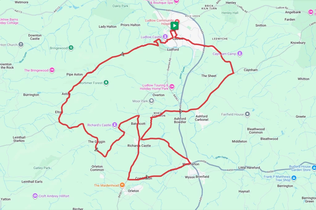
Near the border with Wales, Ludlow in Shropshire provides the base for this ride of two halves. The first half of this ride packs in three tough climbs with gradients up to 15% at one spot; however, there’s plenty of flat ground in the second half to rest those legs. Throw in a couple of castles and some country pubs along the way, and this ride has all the makings of a full day out.
Route Description
From the start point take Station Road and then turn left on to Corve Street, before winding along Bullring and High Street to skirt around Ludlow Castle. After the castle, the route now crosses the River Teme. Shortly after the river crossing, the route takes the left fork in the road, where the first climb of the day starts. Winding along Lower Wood Road, Whitcliffe Road and Killhorse Lane, the next 1.5 miles through Mortimer Forest rise by almost 600 ft.
After cresting the hill, the next couple of miles are then a glorious downhill stretch as the route passes through Aston and on to Elton. The respite is short-lived however, after passing through Elton and continuing along Killhorse Lane the route soon hits its steepest point of the ride before a long descent through The Goggin and on to Richards Castle. Whilst the castle is now only ruins and earthworks, it’s still worth a visit, and your legs could probably do with the rest.
From the Castle, the route now loops around through Batchcott and then proceeds south through the Village of Richards Castle itself and on to the outskirts of Orleton. Heading East now it’s a long, flat run through Comberton and on to the village of Woofferton. After entering Woofferton there’s a short stretch northerly along the A49 for a couple of hundred yards. From Woofferton, Park Lane then takes the route back in the general direction of Richards Castle. From here, the route then uses Mitnell Lane and Wheatcommon Lane, crossing the A49 on its way to Ashford Carbonel.
Continuing along the same route towards Caynhan the route eventually turns along Sheet Road in a generally northern direction. After a few miles, it crosses the A49 for the final time before returning to the start point in Ludlow.
Route Summary
Start Point – Ludlow Railway Station SY8 2PQ, O.S. Grid Ref -SO 51334 75037
Distance – 22.2 miles / 38 km
Elevation Gain – 1847ft / 562 metres
Note – There are a couple of points in the Richards Castle where different sections of the route are quite close. For those wishing to shorten the route, there are options to do so.
Places of Interest
- Ludlow Castle – on the route at the 0.5 mile point.
- Richards Castle – on the route at the 9.0 mile point.
- Caynham Camp Hillfort – just off the route at the 19.6 mile point
Refreshment Stops
- The Mill on the Green Cafe – just off the route at the 0.5 mile point
- The Castle Inn, Richards Castle – on the route at the 10.6 mile point
- Salway Arms Woofferton – on the route at the 13.9 mile point.
- There are several independent and chain cafe’s etc in Ludlow at the start / finish.
Local Bike Shops
- Epic Cycleworks, 7-8 Tower Street, Ludlow, SY8 1RL Tel: 01584 705042
Closest Railway Stations
- Ludlow – at the start / finish point
Ride With GPS Link – https://ridewithgps.com/routes/55064286
GPX file direct download – Click Here
If you liked this route please consider supporting us by buying a tea at www.buymeacoffee.com/cyclinglabs
To see more great routes go to our Routes Index page