
The Tissington Trail and Surrounding Area
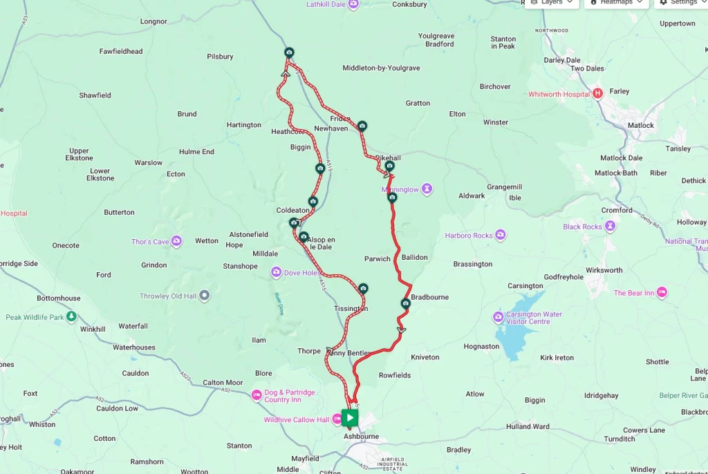
The Tissington trail is an old closed railway line that has been turned into a cycling, walking and horse riding trail. Starting at Ashbourne in Derbyshire, this mainly off-road route takes in both the Tissington Trail and some parts of the National Cycle Network. Approximately 19miles of this route is essentially off-road, so we wouldn’t recommend a road bike for this one. A gravel bike with tyres around 35mm wide and a little tread should be sufficient. The route starts just outside the town of Ashbourne and misses the first mile of the trail, but it is easy to follow the trail back to the town if you want.
Route Description
From the starting point at the Mapleton Road car park, pick up the trail and head north. There’s no need for directions now as the ride sticks to the trail for its first 17.5 miles. With there being no need for navigation in this stretch, take the time to look around and enjoy the views, scenery and some of the attractions on this long disused railway line. After approximately 13.0 miles, National Cycle Network number 54 merges from the right. Take this trail, essentially doubling back on yourself and follow it for another 4.5 miles of off-road gravel riding.
Once NCN 54 arrives at the Minninglow car park, it’s time to leave the gravel for a while and navigate back to the start. From the car park, find Parwich Lane and travel south for approximately 3.5 miles until you come to a ‘T’ junction with the B5056. At this junction, turn right and follow the ‘B’ road for a further 3.5 miles until you come to a junction with the A515. Turning left here, there is an unavoidable but thankfully short stretch along the A515. After about a mile, take the right-hand turning signposted Thorpe, Ilam and Dovedale.
Take this road (Spend Lane) and follow the winding climb for around half a mile. When you come to a bridge over the road, there is a set of steps that take you up onto the bridge and back onto the Tissington Trail, turn left at the top of the steps and follow the trail southward back to the start point.
Route Summary
Start Point – Mapleton Road Car Park DE6 2AA, O.S. Grid Ref -SK 17542 46902
Distance – 26.7 miles / 39 km
Elevation Gain – 1668ft / 469 metres
Places of Interest
- Tissington Village – on the route at the 3.8 mile point.
- Istrian Stone Shelter – just off the route at the 13.0 mile point.
- Arbor Low Stone Circle – just off the route at the 13.0 mile point.
Refreshment Stops
- Herbert’s Fine English Tea Rooms, Tissington – just off the route at the 3.8 mile point.
- Hartington Station Cafe – on the route at the 11.8 mile point.
- Parsley Hay Visitor Centre- just off the route at the 13.0 mile point.
- The Bentley Brook Inn, on the route at the 24.3 mile point.
Local Bike Shops
-
Ashbourne Bike Hire, Adjacent to the car park start point Tel: 01335 343156.
Closest Railway Stations
- There are no railway stations near this route
Ride With GPS Link – https://ridewithgps.com/routes/54380013
GPX file direct download – Click Here
If you liked this route please consider supporting us by buying a tea at www.buymeacoffee.com/cyclinglabs
To see more great routes go to our Routes Index page